
Evans ZIP Codes in Context
Only one current Evans postal ZIP is verified in the research: 80620, with the Evans Post Office listing using the ZIP+4 form 80620-9998. That is a firm postal anchor, but it is not proof that every municipal edge, county parcel, or nearby delivery point uses the same line. No complete official ZIP-by-city list was verified, so a directory that invents a longer Evans ZIP table would overstate the evidence.
| Postal Code | Areas Covered | Post Office | Notes |
|---|---|---|---|
| 80620 | Verified current Evans postal anchor | Evans Post Office | Current postal use; not a municipal boundary |
| 80620-9998 | ZIP+4 office form for the Evans Post Office | Evans Post Office | Specific delivery suffix; not a resident list |
| 80634 | Former Greeley delivery territory cited in the realignment | Historical comparison | Check the date before normalizing to Evans |
The table is deliberately narrow. Evans, Greeley, Garden City, La Salle, and unincorporated Weld locations can touch the same postal and county research area without becoming one municipality. Postal city, municipality, and county are separate labels. A current address needs a USPS check; a property question needs a parcel and situs address; a historic question needs the original line preserved.
For a visual example of ZIP filtering in a Weld record system, the Weld foreclosure search screenshot shows ZIP alongside street, subdivision, status, names, and date-range fields. It demonstrates a search control, not a complete list of Evans addresses.
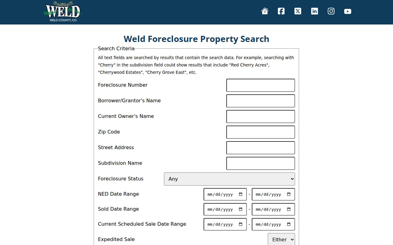
The image helps separate a ZIP filter from a boundary map. A result still needs its record date and custodian before it is treated as evidence about an address.
Note: A ZIP narrows a delivery search, but the underlying parcel, person, or event still requires its own official record.
Evans and the 2001 ZIP Shift
The USPS Postal Bulletin notice records an effective July 1, 2001 realignment that moved former Greeley 80634 delivery territory to Evans 80620. That date matters when a deed, newspaper clipping, directory card, or family letter carries 80634. A modern search that changes the old line without retaining the original can make a correct historical record look wrong.
Use both forms in a research note: write the period address as it appeared, then add a parenthetical current comparison only when the official postal source supports it. The change is a postal normalization clue, not evidence that a person moved or that a parcel changed ownership. The same caution applies when an old directory uses Greeley as the place name for an address now understood as Evans.
- Historical line
- Former Greeley 80634 delivery territory.
- Current comparison
- Evans 80620.
- Effective date
- July 1, 2001.
- Best practice
- Preserve the source line and label any current normalization.
Three USPS ZIP Lookup Paths
The USPS lookup offers three distinct modes. An address search checks a street line. A city and state search helps test the postal city label. A cities-by-ZIP search works in the reverse direction. These modes answer different questions, so a postal directory should not treat one result as a full parcel or resident roll.
| Lookup mode | Useful input | What it can clarify |
|---|---|---|
| By address | Street address and city/state | Current ZIP and ZIP+4 for one delivery point |
| By city and state | City and state fields | Postal place naming and available ZIP choices |
| Cities by ZIP | Postal code | Postal city labels associated with that ZIP |
Search controls include Find and reset behavior, with a USPS disclaimer. Results should be saved with the date because postal products change. The USPS AIS Viewer can help with current ZIP+4 and address-quality products, but it is a formatting and verification tool, not an exportable list of Evans parcels or households.
Note: USPS lookup modes answer different postal questions, so save the mode, inputs, result, and date rather than only the ZIP.
Evans ZIP Filters in Weld Records
A postal code can be a field inside a larger Weld search, but each system describes a different record relationship. The Weld Assessor office property search is built around an owner, address, account, subdivision, parcel, section-township-range, or API number. Its sample property report can show a property address, owner mailing address, legal description, valuation, document history, and map links. It does not create a public resident roster merely because a ZIP is entered.
| System | ZIP role | Result to verify | Access note |
|---|---|---|---|
| Weld foreclosure search | Filter with names, street, subdivision, status, dates | Foreclosure record and date range | Separate from parcel ownership |
| Colorado voter lookup | Lookup input and address context | Public voter fields when a match is returned | Confidential voters and sensitive fields are withheld |
| Weld property search | Address text and parcel context | Situs, owner, mailing, account, legal data | Assessor record, not occupancy proof |
That distinction protects against a common error. A postal label, a foreclosure search hit, a voter match, and an assessor owner record are not interchangeable. The Weld tax-information guidance likewise treats the tax-notice address and owner-of-record context as a separate layer. Record the system, query, date, and relationship shown by the result.
Finding Evans Residents by ZIP
A ZIP-based resident search works best as a sequence, not as one broad claim. Begin with a postal check, then use the county or state record that fits the question. If the goal shifts to a named street, the Evans street directory provides the next address-level path.
- Check the complete address in the USPS ZIP Lookup, and save the returned ZIP, ZIP+4, city label, and search date.
- Use Weld Property Data Search by address, owner, account, parcel, or subdivision. Compare the physical property address with the owner mailing address.
- Open the Weld GIS Property Portal to check parcel shape, address labels, and neighboring geography rather than assuming the ZIP draws the city line.
- For election research, use Colorado Find My Registration and respect its mismatch notice, withheld fields, and confidential-voter exclusions.
- Carry the verified street and date into the recorder, newspaper, or directory source that actually covers the person or property question.
A ZIP-wide result can be useful for narrowing a family-history search or checking a historic postal change. It cannot prove that every person at an address is listed, that an owner lives there, or that a nearby property shares the same municipal status.
Note: A ZIP-wide lead becomes more useful when the street, source date, and record relationship remain attached to the query.
Evans Postal Labels Tell a Story
The 80634-to-80620 shift is a small but useful records-history story. Evans grew within a landscape of South Platte, Union Pacific, US 85/34, and neighboring Greeley, Garden City, and La Salle geography. A postal city can therefore be a practical delivery label while a county record follows a parcel, legal description, or municipal office. The labels overlap in daily life but separate in a careful search.
For older Evans material, write down the name used by the source, including Greeley or a precinct reference, then compare it with the later Evans label. The city street locator is also worth checking because 31st, 32nd, 34th, 35th, 36th, 37th, and 42nd Street ranges have gaps, odd or even splits, or separated segments. A missing street range may be an address-format problem, not a missing person.
Evans ZIP Search Fallbacks
A ZIP result that does not resolve an Evans address should move to the next custodian, not to a guessed nearby city. The Weld Assessor can test the address, owner, account, parcel, subdivision, section-township-range, and API routes at 970-400-3650. The Elections Department at 1250 H Street, Greeley, can explain county registration records and request channels at 970-304-6525. The Clerk & Recorder can test a legal description or recorded party at 970-304-6530. Each office sees a different relationship to the address.
Historical ZIP work has its own fallback chain. Keep the original line from the directory, tax notice, newspaper, deed, or letter. Search the Weld County Master Index, Evans Journal, Greeley Tribune, HPLD newspaper resources, and the Greeley History Research Center for the same street and date. Then compare the historic wording with the current street locator and GIS parcel. A current USPS result can normalize a delivery line, but it cannot rewrite the historical evidence.
When an online form is unavailable, use the official office phone, mail route, or a written Colorado Open Records Act request where the record category allows one. The county’s foreclosure reports, foreclosure-law guidance, and online-sale information are event-specific routes rather than resident lists. State the ZIP, street, date range, and record type. Ask whether the office holds a parcel record, election record, tax item, or historical reference before sending personal information.
Dates Make Evans ZIP Evidence Useful
Every ZIP code directory result needs a date because delivery areas, parcel layers, voter data, and foreclosure notices change at different speeds. Label a USPS check with the search date. Label an assessor report with its tax year. Label a voter match with the lookup date. Preserve the effective date of the 2001 postal bulletin beside any 80634 record. A directory or newspaper entry should carry its publication year even when the street still exists. A Weld tax-lien sale is another dated event, not a permanent resident field.
This dating also prevents a present map from being projected into the past. A 2022 zoning map can describe current Evans geography, while a 1904 Sanborn sheet describes buildings and streets in an earlier setting. A county foreclosure search can show an event-specific notice, while a property report describes a parcel snapshot. A ZIP is helpful when those records are joined, but it is never the sole proof of a resident, owner, or municipal boundary.
ZIP Codes and Evans City Limits
Postal boundaries are delivery areas. Evans city limits are municipal geography. Weld County parcels, tax districts, voter precincts, postal cities, and historical town references add more lines. The 2022 Evans zoning map shows city limits, parcels, US 85, the South Platte River, and surrounding municipalities, but it is dated and should be paired with current GIS. No static official list was verified that would turn the postal directory into a complete municipal boundary table.
Boundary check. Treat 80620 as a verified postal anchor, not a shortcut for city limits or a list of current occupants. Confirm the parcel and record custodian before drawing a conclusion.
- Postal code
- A delivery-area label used to sort and route mail, not a parcel or city boundary.
- ZIP+4
- A ZIP plus four digits that narrows a delivery point, such as a specific office or route.
- Postal city
- The city label used for delivery. It may differ from the municipality where a parcel sits.
- Situs address
- The physical location tied to a parcel. It can differ from an owner’s mailing address.
- Carrier route
- A postal delivery route within a ZIP. It is not a public neighborhood or resident directory.
Use the postal directory for the delivery question, then hand the address to the office that holds the underlying record. That keeps a useful search key from becoming an unsupported boundary claim.
Note: Confirm a postal label, municipal boundary, and parcel situs separately because each belongs to a different custodian and date.